Overview
It focuses on solving the difficult 3-7 day long-term typhoon forecast problem and develops some new integrated schemes or algorithms for operational typhoon track, intensity and scale or structure forecast. The results of the project will be directly applied to operational typhoon forecasting in China, improve the ability to forecast 3-7 days of typhoons, and play an active role in national disaster prevention and reduction.
Highlights
1. TC Intensity Prediction Scheme based on logistic growth equation for Western North Pacific (LGEM-WNP)
An intensity prediction scheme of tropical cyclones (TCs) based on the logistic growth equation (LGE) for the western North Pacific (WNP) has been developed using the machine learning method called Long Short-Term Memory (LSTM). In the LGE, TC intensity change is determined by a growth term and a decaying term. These two terms comprise four free parameters, including the time-dependent growth rate and maximum potential intensity (MPI), and two constants. With training samples from the observation, optimal predictors are selected first, and then the two constants are determined based on the least square method, making the regressed growth rate from the optimal predictors as close to the observed as possible. The growth rate is further estimated based on LSTM for the period. Then, we transfer the learned features in the observations to perform further training for the Global Forecast System (GFS) forecast data in the past years. Finally, TC intensity forecasts are conducted based on the GFS environmental forecasts and CMA TC track forecasts.
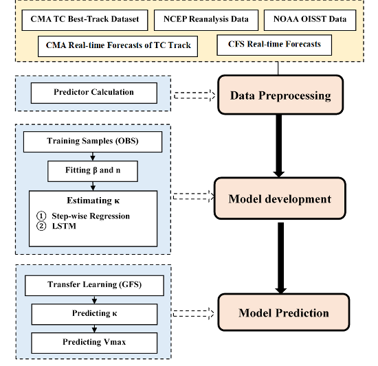
Figure. The flow chart of TC intensity prediction scheme based on logistic growth equation for western North Pacific (LGEM-WNP)
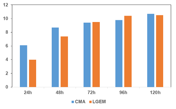
Figure. The comparison of TC intensity errors of LGEM-WNP and CMA subjective forecast in 2015-2017
2. TC Intensity Prediction Scheme based on the energetically based dynamical forecast system for Western North Pacific (EBDS-WNP)
An intensity prediction scheme of tropical cyclones (TCs) based on the energetically based dynamical system (EBDS) for the western North Pacific (WNP) has been developed using the machine learning method called Long Short-Term Memory (LSTM). In the EBDS, a dynamical efficiency is introduced to the intensification potential of a TC system. The dynamical efficiency E (0≤??≤1) reflects the effective conversion of potential energy production to kinetic energy production for the TC system. The EBDS comprises four free parameters, including the time-dependent E, maximum potential intensity, surface drag coefficient, and undetermined height parameter. The last two parameters are considered as constants. With training samples from the observation, optimal predictors are selected first, and E is further estimated based on LSTM for the period. Then, we transfer the learned features in the observations to perform further training for the Global Forecast System (GFS) forecast data in the past years. Finally, TC intensity forecasts are conducted based on the GFS environmental forecasts and CMA TC track forecasts.
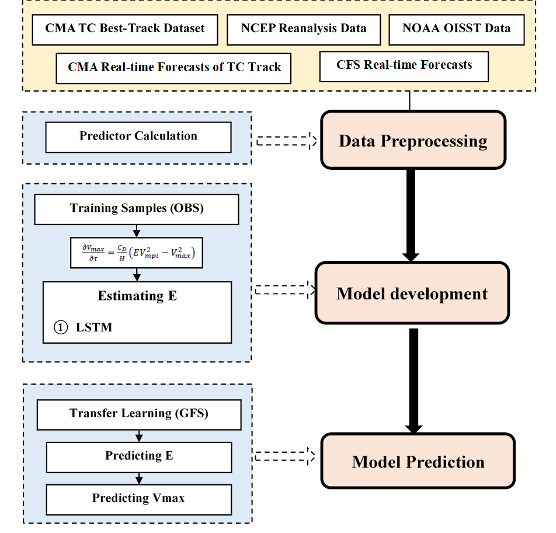
Figure. The flow chart of TC intensity prediction scheme based on the energetically based dynamical forecast system for Western North Pacific (EBDS-WNP)
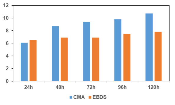
Figure. The comparison of TC intensity errors of EBDS-WNP and CMA subjective forecast in 2015-2017
3. Typhoon track ensemble correction algorithm (TYTEC) based on the depth series model (AI-TYTEC)
The typhoon track ensemble correction algorithm (TYTEC) based on the depth series model (conv-lstm) (Figure 1) has been preliminarily developed, and the deep learning method based on ECMWF ensemble prediction has been designed. The learning data uses the typhoon prediction path of 51 members of EC ensemble prediction and 52 models of deterministic prediction, as well as the real-time typhoon positioning of the National Meteorological Centre. Based on the 6-hour prediction error feedback mechanism, the typhoon track AI prediction model (AI-TYTEC) is established. The model scrolls and corrects the prediction weight of each member every 6 hours, and recalculates the corresponding objective path prediction according to formula 1. Based on the evaluate result, for all typhoons from 2012 to 2019, the depth learning model is used to compared with the numerical model (or ensemble average prediction) with the best performance in the same period. The result shows that the 24-hour prediction error of the depth learning model is about 15 ~ 20% less than that of the best numerical model. Furthermore, the AI-TYTEC can extend the TC track forecast up to 7 days.

Figure. The technical flow chart of TYTEC (left) and the process flow of TYTEC-AI (right)
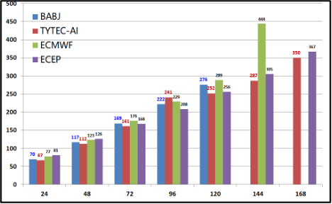
Figure. The technical flow chart of TYTEC (left) and the process flow of TYTEC-AI (right)
4. Integrated Typhoon Track Forecast Scheme Based on Intelligent Computing Algorithm (ITFS-ICA)
Based on several kinds of numerical prediction products and RJTD products, the members of the European Central typhoon ensemble forecast are sorted by the optimal forecast track method, and the first best T prediction members are formed as a factor matrix X. Furthermore, under the same independent sample with the same years, the cross modeling prediction has been conducted for the factor matrix X using the intelligent computing methods of generalized regression neural network, the regression random forest algorithm and the partial least squares algorithm. In this way, three sequences Y={y1,y2,y3} with the same samples as the factor matrix X are obtained. Finally, the objective and quantitative forecast of the Northwest Pacific typhoon track has been developed using the multiple regression model for quadratic modeling and based on the matrix composed of Y, X and RJTD products as model input.
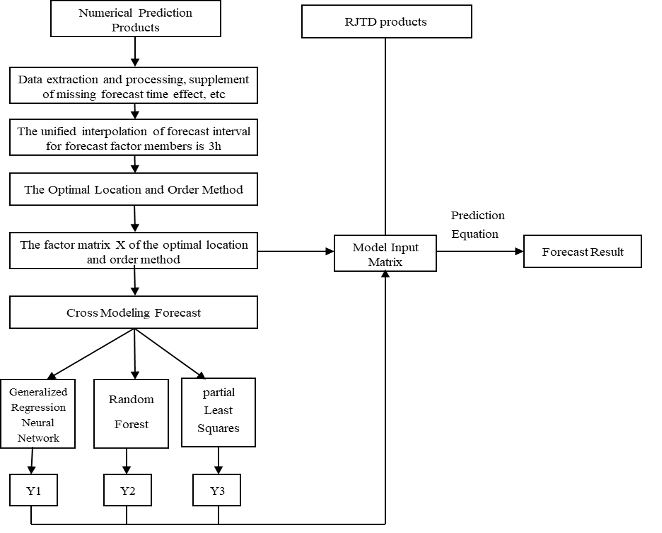
Figure. The technical flow chart of ITFS-ICA

Figure. The Comparison of track errors of ITFS-ICA, CMA subjective and ECMWF EPS mean forecast in 2020(left) and 2021(right) operation
5. WRF/EnKF ensemble analyses for western North Pacific
The 5~7-day ensemble forecasts for Tropical Cyclones (TC) of western North Pacific are provided using an ensemble predication system based on WRF model. The system contains 80 members with initial conditions from the WRF/EnKF ensemble perturbed members (link to “Dataset: WRF/EnKF ensemble analyses for western North Pacific”). For years 2016-2018, the model domains covered triple meshes with a grid spacing of 18-km (grid size 660 x 520) for the outermost domain and grid spacings of 6-km (grid size 180 x180) and 2-km (grid size 360 x360) for two vortex-following domains. There are 57 vertical levels with model top at 10 hPa. The implementation of WRF has the following components: the WRF 6-class microphysics scheme, the Yonsei University (YSU) planetary boundary layer (PBL) scheme, the Noah land surface model, the Rapid Radiative Transfer Model for global models long-wave and shortwave scheme are used. The Tiedtke cumulus scheme is only used for the 18-km domain. The forecast time length is up to 5 days. Since year 2019, the model domains has been changed to two meshes with a grid spacing of 12-km (grid size 720 x 560) for the outermost domain and a grid spacing of 2.4-km (grid size 400 x 400) for the vortex-following domain. The forecast time length is extended to 7 days. Unlike previous versions, the Multi-scale Kain-Fritsch (MSKF) cumulus scheme is adopted in both domains.
6. Typhoon Regional Assimilation and Prediction System (T-RAPS)
Typhoon Regional Assimilation and Prediction System (T-RAPS) is an operational typhoon predicting system which is basing on the WRF numerical model. With the vortex dynamic initialization scheme and topographic filtering scheme, the intensity, structure and location of the target typhoon in initial field is adjusted and relocated according to the observation: when typhoon in initial field (T0h) is obviously weaker than observation in the developing stage, an integration is conducted from 6 hours before T0h (T0-6h) with WRF model to obtain a stronger vortex. If the intensity difference is not small enough, the obtained stronger vortex will replace the vortex at T0-6h and the integration will be conducted again. This cycle will continue until the difference is small enough. Specified topographic filtering scheme is also applied for vortex in different distance to coastline. These schemes improve the initial vortex on the surface with complicated terrain. An air-sea coupling scheme is also employed in the predicting process to improve the intensity forecasting skill.
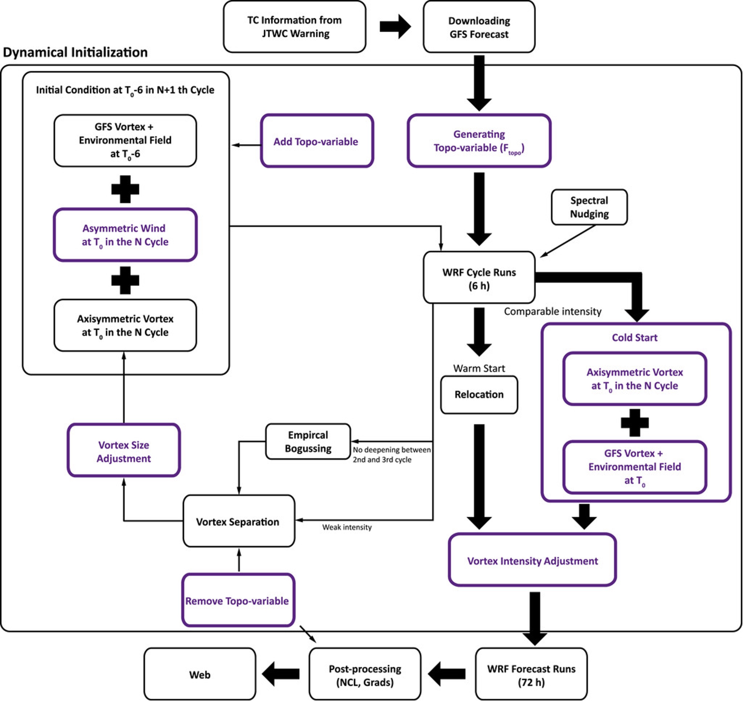
Figure. The technical flow chart of Typhoon Regional Assimilation and Prediction System (T-RAPS)
7. Typhoon intensity and size estimation algorithm based on DeepTCNet
Intensity and size are principal attributes of tropical cyclones for these largely determine the tropical cyclone deaths and economic damages. The DeepTCNet product and supporting real-time guidance are designed to offer quick, objective and skillful estimations of TC intensity and size from satellites. It is not intended to substitute for the official guidance from TC warning centers, but rather to provide the community and forecasters supplemental references. The DeepTCNet intensity data are provided beginning from storm formation to dissipation, and the size will be provided when the storm reaches a specific wind threshold.
DeepTCNet is a deep convolutional neural network as backend technique proposed to determine tropical cyclone intensity and size from geostationary satellite infrared imagery. The required input of algorithms is infrared imagery (~11μm). All imageries are pre-processed to be centered on the TC location at the time of image from a Full Disk of geostationary satellites with 0.07 deg lat/lon grid; 156x156 pixels. In real time, the TC center position uses a short-term forecast track, interpolated to the time of the satellite image, from an applicable operational forecast center; given DeepTCNet tolerances less precise TC center locations. The outputs of algorithms are the resulting TC intensity and size. Overall, DeepTCNet models a relationship between the infrared imagery of TC and the intensity and size [i.e., Intensity/Size = f (IR)].
The original version of DeepTCNet described in Zhuo and Tan (2021) is developed with data of North Atlantic TCs. To generalize the method to the western North Pacific, transfer learning was applied. In particular, only the highest quality part of the JTWC best-track records was considered.
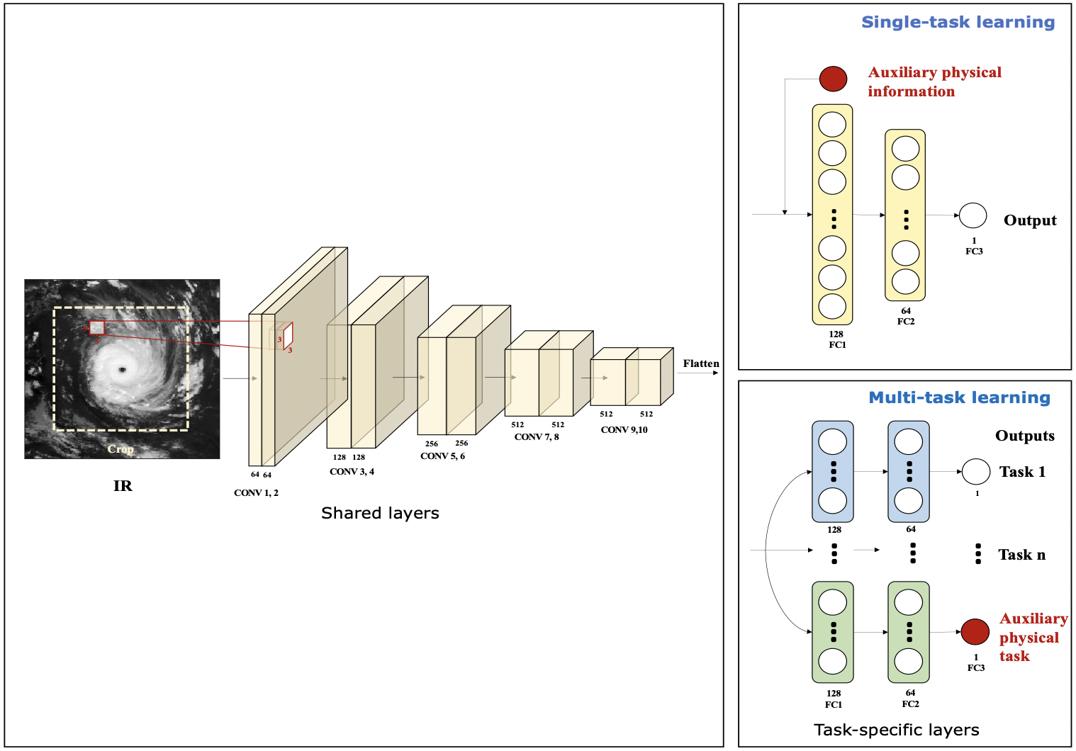
Figure. The con?guration of DeepTCNet in both single-task and multitask learning frameworks
8. Typhoon Wind Radii Forecast using Climatology Persistence(TRF-CLIPER)
With a modified Rankine Vortex, the radial profiles of typhoon wind speed in different quadrants (ie. NE, SE, SW and NW) can be represented by a typhoon’s latitude, translation speed and maximum wind speed, which could be regarded as the climatological factors of typhoon’s wind radii. Fitting the Rankine Vortex equation by the historical typhoon data, a regression equation of climatology is obtained by which the wind radii can be resolved. Assuming that the forecast radial profiles approach the climatological ones gradually with forecast time, the climatological part of the wind radii of every forecast leading can be calculated by substituting the climatological parameters of typhoon into the equation. And there is a deviation between the estimated wind radii and the climatological part at the synoptic time. Consider the deviations decay exponentially over time, the radii deviation of each forecast leading time can be obtained. Finally, the forecasted deviations are added back to the climatological wind radii of each forecast time to obtain the final wind radii forecast.
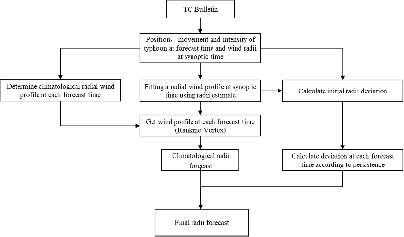
Figure. The technical flow chart of Typhoon Wind Radii Forecast using Climatology Persistence (TRF-CLIPER)
9. Typhoon Wind Radii Forecast using Climatology Persistence(TRF-CLIPER)
With a modified Rankine Vortex, the radial profiles of typhoon wind speed in different quadrants (ie. NE, SE, SW and NW) can be represented by a typhoon’s latitude, translation speed and maximum wind speed, which could be regarded as the climatological factors of typhoon’s wind radii. Fitting the Rankine Vortex equation by the historical typhoon data, a regression equation of climatology is obtained by which the wind radii can be resolved. Assuming that the forecast radial profiles approach the climatological ones gradually with forecast time, the climatological part of the wind radii of every forecast leading can be calculated by substituting the climatological parameters of typhoon into the equation. And there is a deviation between the estimated wind radii and the climatological part at the synoptic time. Consider the deviations decay exponentially over time, the radii deviation of each forecast leading time can be obtained. Finally, the forecasted deviations are added back to the climatological wind radii of each forecast time to obtain the final wind radii forecast.

Figure. The technical flow chart of Typhoon Wind Radii Forecast using Climatology Persistence(TRF-CLIPER)
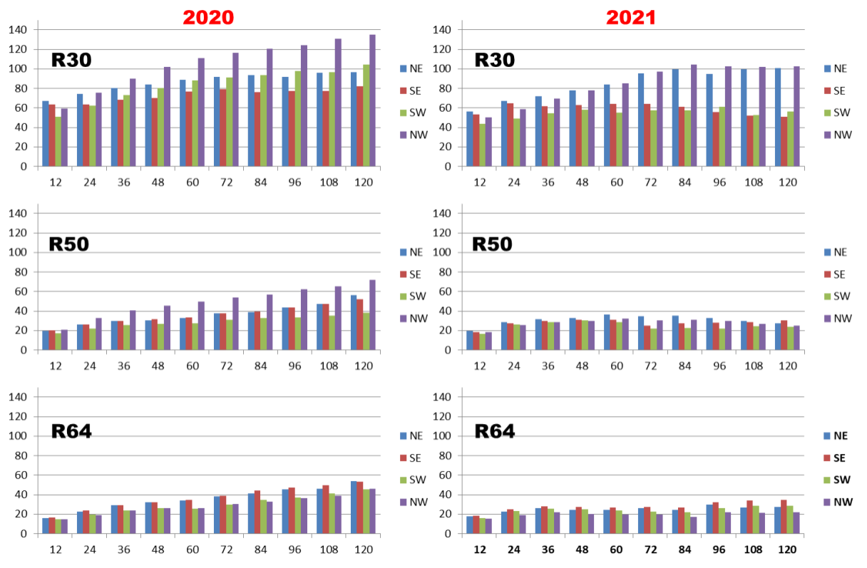
Figure. TRF-CLIPER Forecast Error for Wind Radii in 2020-2021
10. Typhoon Wind Radii Forecast using Numerical Weather Prediction Model(TRF-NWPM)
The main idea of this method is to adjust the surface wind (10 meters above ground) from numerical weather prediction model (NWPM) according to subjective intensity forecast. While keeping the wind structure resolved by the model, the forecasted intensity predicted is consistent with the subjective forecast. The detailed scheme is as follows: firstly, the model surface wind is converted into a polar coordinate centered at the typhoon center, so that the maximum surface wind speed near the center of the typhoon can be located. The corresponding radius will be used as the radius of maximum wind (RMW) of the typhoon, and the wind profile in this direction is defined as the prototype profile. Secondly, a target wind speed profile is established using the model RMW, subjectively predicted typhoon maximum wind speed, a wind speed of 9m/s and it’s corresponding radius at prototype profile direction. Thirdly, for different radii from typhoon center, a series of regression relationships between the prototype profile and the target profile are established separately, and then applied to all the other directions of the NWPM surface wind to generate a modified surface wind field. Finally, the wind radii of 30, 50 and 64 knot wind speed in the four quadrants (northeast, southeast, southwest and northwest) can be find in the modified surface wind field..
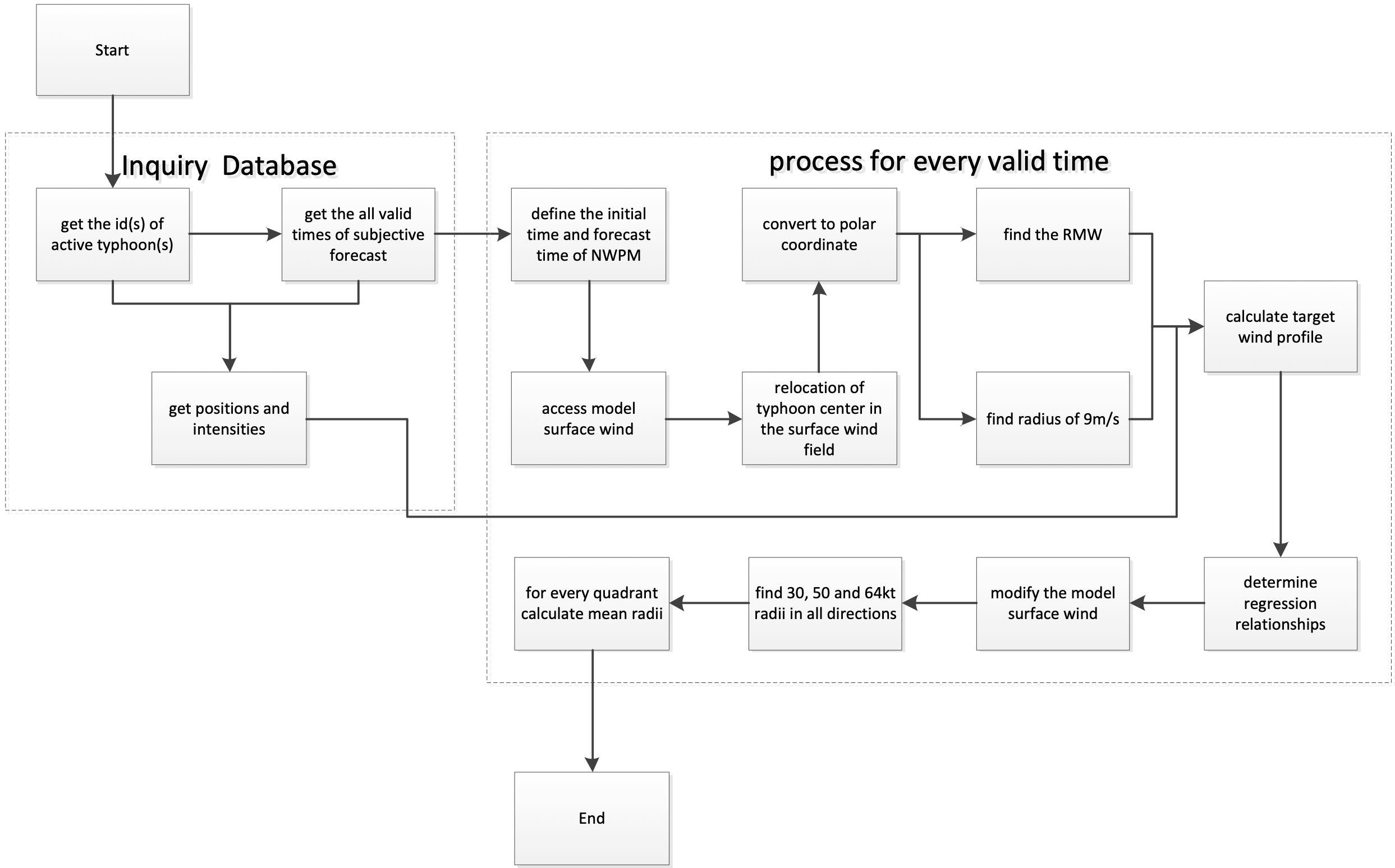
Figure. The technical flow chart of Typhoon Wind Radii Forecast using Numerical Weather Prediction Model(TRF-NWPM)
11. Tropical cyclone Wind Radii Forecast method based on Georgiou wind field model (STI-RF-G)
A wind Radii of 13.9 m/s, 24.5 m/s, and 32.7 m/s forecast method for tropical cyclone in the Northwest Pacific Ocean and the south China sea based on subjective track intensity forecast and parametric wind field model (named as STI-RF-G) is developed. Here the Georgiou wind field model, which can reflect the equilibrium equation of the tropical cyclone vortex kinematics, is chosen as the simplified wind model. The detail of the method is shown as follows:
Forecast region :western North Pacific Ocean and the south China sea;
Forecast time range :Yearly;
Forecast interval :120 h / 6 h;
Forecast times:Four times a day, including 02:00, 08:00, 14:00, 20:00 (BJT);
Operating conditions:Babj*.dat exists.
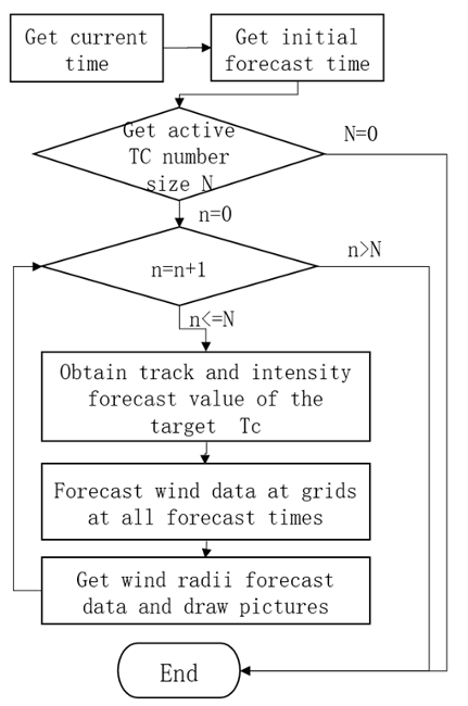
Figure. T The process chart of STI-RF-G
12. Tropical cyclone Wind Radii Forecast method based on improved CE wind-field model (STI-RF-C)
A wind Radii of 13.9 m/s, 24.5 m/s, and 32.7 m/s forecast method for tropical cyclone in the Northwest Pacific Ocean and the south China sea based on subjective track intensity forecast and parametric wind field model (named as STI-RF-G) is developed. Here the improved CE wind field model by Shanghai Typhoon Institute, is chosen as the simplified wind model. Characteristics of key parameters including the radius of maximum wind and the Holland-B parameter are revised based on investigated for historical typhoons in the western North Pacific Ocean . Comparisons show that the wind field model has a high reliability in capturing the wind field characters within 250 km from the typhoon center. The detail of STI-RF-C is shown as follows:
Forecast region :Northwest Pacific Ocean and the south China sea;
Forecast time range :Yearly;
Forecast interval :120 h / 6 h;
Forecast times:Four times a day, including 02:00, 08:00, 14:00, 20:00 (BJT);
Operating conditions:Babj*.dat exists.
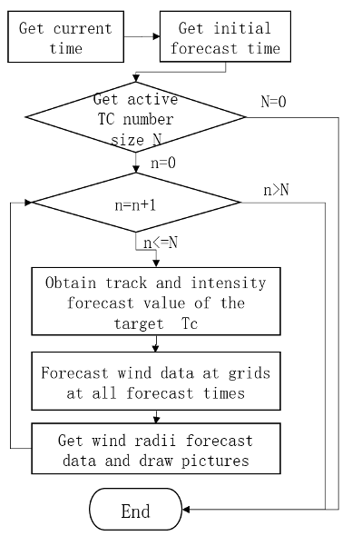
Figure. The process chart of STI-RF-C
References
Lei, L. L., Y. J. X. Ge, Z.-M. Tan, Y. Zhang, K. K. Chu, X. Qiu, and Q. F. Qian. 2022: Evaluation of a regional ensemble data assimilation system for typhoon prediction. Adv. Atmos. Sci., https://doi.org/10.1007/s00376-022-1444-4.
Zhou, Y. C., J. W. Zhao, R.-F. Zhan, P. Y. Chen, Z. W. Wu, and L. Wang, 2021: A Logistic-Growth-Equation-based tropical cyclone intensity prediction scheme for the western North Pacific. Adv. Atmos. Sci., 38, 1750-1762, doi: 10.1007/s00376-021-0435-1.
Zhuo, J. Y., and Z. M. Tan, 2021: Physics-Augmented Deep Learning to Improve Tropical Cyclone Intensity and Size Estimation from Satellite Imagery. Monthly Weather Review, 149, 2097-2113.
QIAN Qi-feng, ZHANG Chang-an, GAO Shuang-zhu, ZHANG Ling, DONG Lin, 2014: Real-time correction method for ensemble forecasting of typhoon tracks (in Chinese). Journal of Tropical Meteorology, 30(5), 904-910.
Contact
For any comments and questions about TC Intensity Prediction Scheme based on logistic growth equation for Western North Pacific (LGEM-WNP) and TC Intensity Prediction Scheme based on the energetically based dynamical forecast system for Western North Pacific (EBDS-WNP), please contact zhanrf@fudan.edu.cn
For any comments and questions about Typhoon track ensemble correction algorithm (TYTEC) based on the depth series model (AI-TYTEC), please contact qianqf@cma.gov.cn
For any comments and questions about Integrated Typhoon Track Forecast Scheme Based on Intelligent Computing Algorithm (ITFS-ICA), please contact xuyl@cma.gov.cn
For any comments and questions about WRF/EnKF ensemble analyses for western North Pacific, please contact zhangjin@cma.gov.cn
For any comments and questions about Typhoon Regional Assimilation and Prediction System (T-RAPS), please contact huangyiwu@cma.gov.cn
Typhoon intensity and size estimation algorithm based on DeepTCNet, please contact jyzhuo@smail.nju.edu.cn
For any comments and questions about Typhoon Wind Radii Forecast using Climatology Persistence(TRF-CLIPER)and Typhoon Wind Radii Forecast using Numerical Weather Prediction Model(TRF-NWPM), please contact niegaozhen@cma.gov.cn
For any comments and questions about Tropical cyclone Wind Radii Forecast method based on Georgiou wind field model (STI-RF-G) and Tropical cyclone Wind Radii Forecast method based on improved CE wind-field model (STI-RF-C), please contact chenpy@typhoon.org.cn