Overview
Data assimilation plays a critical role in improving the skills of numerical weather prediction by establishing accurate initial conditions. Especially for forecasting tropical cyclones (TCs), multiscale data assimilation algorithm and ensemble sensitivity analysis, strategies combating dynamically inconsistent and imbalanced initial conditions, and effective usage of advanced observations like the satellite radiances, are investigated.
Highlights
1. Localization for satellite radiances in an ensemble Kalman filter
Assimilating satellite radiances can significantly improve the prediction of tropical cyclones (TCs) whose lifetimes are most over the tropical ocean with limited conventional observations. For the widely used ensemble Kalman filter (EnKF), one important aspect of its successful implementation in high dimensional applications is covariance localization, which is applied to mitigate sampling errors and avoid filter divergency. For satellite radiances whose vertical locations are not well defined, covariance localization is not straightforward for the EnKF. One strategy is to implement model-space localization in an EnKF (Lei et al. 2018). Through a modulation approach, an expanded ensemble that have model-space localization implicitly applied is generated from the raw ensemble and eigenvectors of the localization matrix. Results confirm that EnKF with model-space vertical localization performs better than observation-space vertical localization. The other strategy is to implement adaptive observation space localization for the EnKF (Lei et al. 2020). Using the adaptive global group filter, three localization parameters, including the localization width, maximum value, and vertical location of the radiance observations, can be adaptively estimated for each assimilated channel of every satellite platform. Furthermore, it is beneficial to differentiate the localization parameters for TC and non-TC regions and vary the localization parameters with time (Wang et al. 2020). For typhoon Yutu (2018), the adaptively estimated localization parameters better capture the onset of rapid intensification (RI) and yield improved intensity and structure forecasts compared to the default localization.
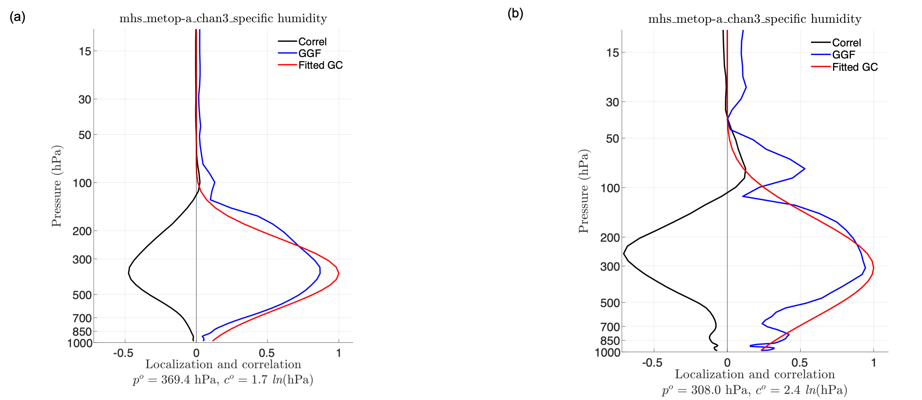
Figure. The mean sample correlations (black), adaptively estimated localization functions (blue), and fitted Gaspari and Cohn (GC) localization functions (red) for channel 3 of MHS onboard MetOP-A radiances with state variable temperature, for (a) non-TC and (b) TC regions.
2. Four-dimensional incremental analysis update
The analyses produced by intermittent data assimilation methods can be dynamically inconsistent and unbalanced. By gradually distributing the analysis increment along model integration, incremental analysis update (IAU) is effective to combat the inconsistences and imbalances. The commonly used IAU computes analysis increment once and assumes it to be constant for an assimilation window, which can be seen as a three-dimensional IAU (3DIAU). The propagation of the analysis increment in the assimilation window is neglected, yet this propagation may be important, especially for moving weather systems, like the tropical cyclones (TCs). To take into account the propagation of the analysis increment during an assimilation window, a four-dimensional IAU (4DIAU) is presented, which constructs time-varying analysis increments by applying all observations in an assimilation window to state variables at different times during the assimilation window (He et al. 2020). Results show that for state variable that carries the signal of the external gravity mode and is sensitive to imbalances, 4DIAU has smaller errors than 3DIAU that has smaller errors than no IAU, despite that the differences among the experiments decrease with increasing assimilation frequency. For typhoons Lingling (2019) and Hagibis (2019), experiments with IAU obtain better intensity and structure of TCs than the control experiment (Ge et al. 2022). Due to the displacement errors in priors and posteriors, the advantage of 4DIAU is limited compared to 3DIAU. As a tradeoff between the filtering and time-varying increment, 4DIAU with 3-h increment could be preferred for TCs.
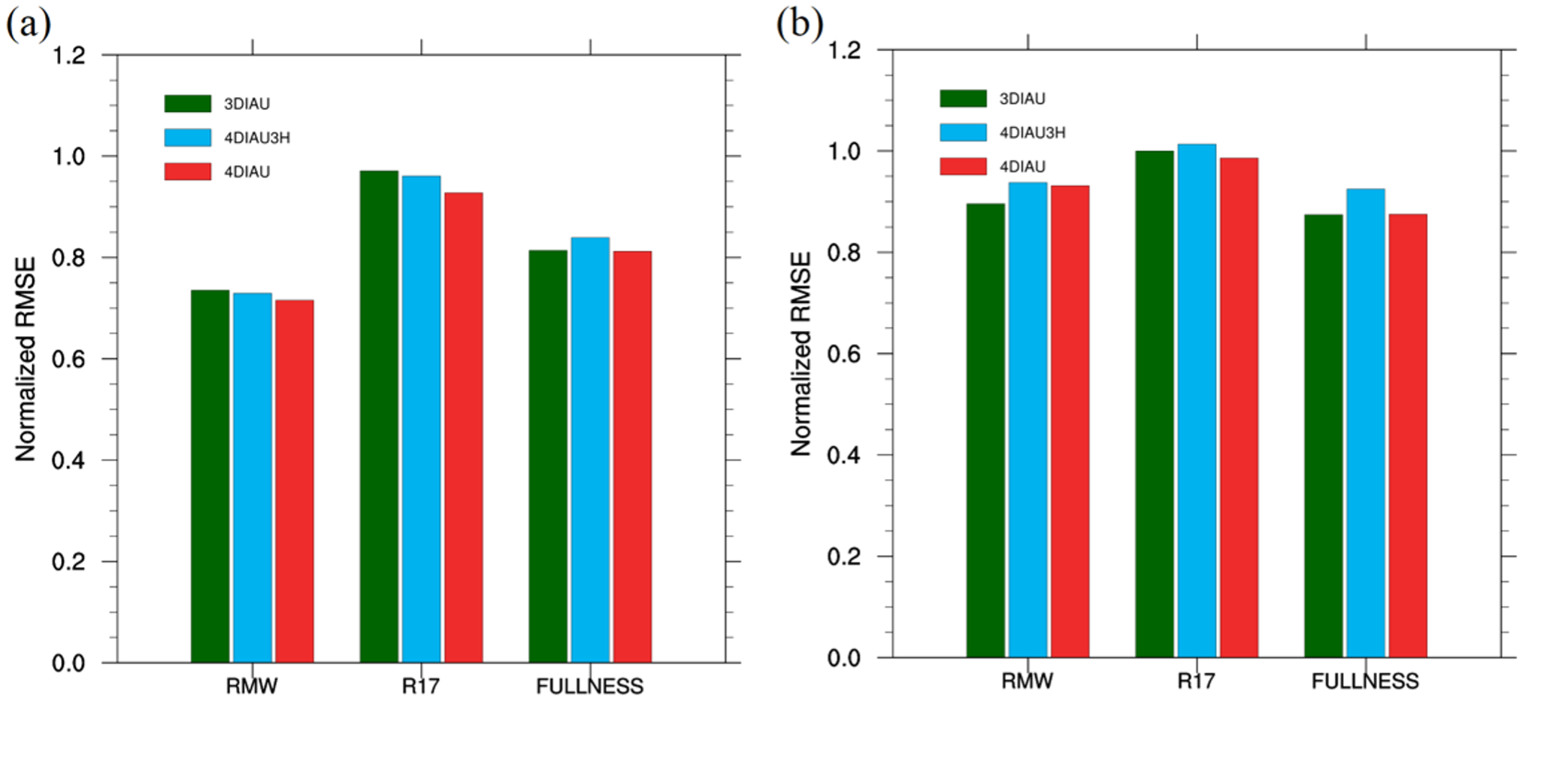
Figure. Normalized errors of radius of maximum wind (RMW), radius of gale‐force wind (R17), and fullness from each assimilation experiment compared to experiment CTRL for typhoons (a) Hagibis and (b) Lingling.
3. Multivariate ensemble sensitivity analysis
Ensemble sensitivity analysis provides an objective and quantitative way to evaluate the impact of changes in initial conditions on subsequent forecasts. Typically, ensemble sensitivity, as a univariate regression, calculates the response to a forecast metric resulted from each state variable on a grid independently and neglects the covariances across state variables. The univariate ensemble sensitivity can overestimate the response of a forecast metric to initial perturbations, which possibly results from sample error. To remedy this overprediction, the multivariate ensemble sensitivity that accounts for collective contributions to the forecast metric from all the initial perturbation variables simultaneously is proposed. To demonstrate the multivariate ensemble sensitivity in a realistic application, especially with multiscale flows, a high-resolution ensemble forecast of Typhoon Haiyan (2013) is used (Ren et al. 2019). To increase the predicted Haiyan’s intensity, multivariate ensemble sensitivity gives initial perturbations characterized by a warming area around the center of the storm, an increased moisture area around the eyewall, a stronger primary circulation around the radius of maximum wind, and stronger inflow at low levels and stronger outflow at high levels. Perturbed initial condition experiments verify that the predicted response from the multivariate sensitivity is more accurate than that from the univariate sensitivity. Moreover, the initial dry dynamical differences play a more important role than the initial moist differences for the intensity changes of Typhoon Haiyan (2013).
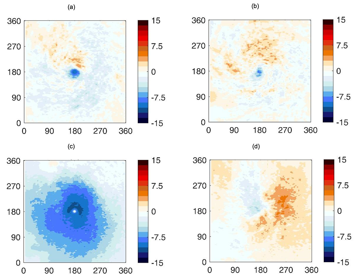
Figure. The estimated multivariate ensemble sensitivity of (a) potential temperature, (b) water vapor mixing ratio, (c) tangential wind, and (d) radial wind at 850 hPa with lead time 24 h.
4. A new type of Red-Green-Blue composite with application for typhoon positions
The center positions of weak TCs are difficult to define in operational forecasts. To solve this problem, a TC-red-green-blue (TC-RGB) composite was designed by using satellite multi-channel observations (reflectance, brightness temperature, and brightness temperature differences). Compared to single channel images, TC-RGB composites clearly show the exposed low-level circulation (LLC) of weak TCs under large vertical wind shear. Based on the guidelines of TC-RGB composites for TC center positioning, 83 western North Pacific (WNP) TC cases during 2017–2019 are examined, verified to the Regional Specialized Meteorological Centre-Tokyo (RSMC-Tokyo), the Joint Typhoon Warning Center (JTWC) and the China Meteorological Administration-Shanghai Typhoon Institute (CMA-STI). For TC Kalmaegi (2019), the best-track data from the RSMC-Tokyo, JTWC and CMA-STI have over 100 km biases at the early stage of TC life. Based on the 83 TC cases, results show that the average center position biases and standard deviations for weak TCs under small vertical wind shear in the daytime are 5 km larger than those under large vertical wind shear at nighttime. With clear LLC centers, the difference of these two biases is 10 km. The average biases are mostly above 20 km in the areas south of 18° N and north of 36° N over the WNP. Conversely, in the areas between 18° N and 36° N over the WNP, the average biases are mostly below 20 km.
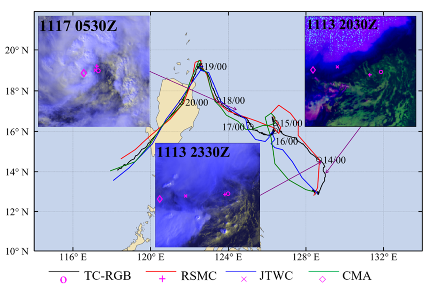
Figure. Tracks of TC Kalmaegi (2019) from the three best-track datasets (red, blue, and green lines for RSMC-Tokyo, JTWC, and CMA-STI, respectively) and the TC-RGB-based method (black line). Purple lines link inset figures of TC-RGB composites to the approximate TC locations on the track. TC center positions from the three agencies and TC-RGB-based method are indicated by magenta markers (+:RSMC-Tokyo; ×: JTWC; ?: CMA-STI; o: TC-RGB).
5. A new cloud product dataset for radiance data assimilation in cloudy conditions
Cloud thermodynamic phase, cloud optical thickness (τ) and cloud-top particle effective radius (Re) are the basic parameters of the fast radiative transfer modes (e.g., CRTM and RTTOV) that are widely used in cloudy radiance simulations. Accurate observations of these parameters are the key to improve the radiance data assimilation in cloudy conditions. Thus a dataset composed of 30 cloud properties is established from the measurements of Advanced Himawari Imager (AHI) onboard Himawari-8 satellite. This dataset covers the majority of the North Pacific and East Asia spanning 10°~50°N, with a spatial resolution of 2 km. The cloud products are available from 2016-2021 at 30-min intervals. Evaluated using Cloud–Aerosol Lidar with Orthogonal Polarization (CALIOP) products over a 4-month period from March to June of 2017, the AHI-based cloud-top determinations give hit rates of 80.20% and 86.51% for CALIOP water and randomly-oriented-ice cloud tops, respectively. Compared to the Collection-6 Moderate Resolution Imaging Spectroradiometer (MODIS) Level-2 cloud product (MOD06), the AHI cloud product significantly reduces the number of unreasonable ice-phase pixels over oceans and uncertain-phase pixels over land. The AHI-retrieved τ and Re are also in good agreement with the MOD06 product. The correlation coefficients of τ and Re between the AHI retrievals and MOD06 products are 0.76–0.89 and 0.63–0.87, respectively.
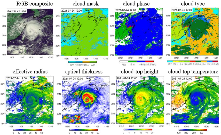
Figure. Cloud products for typhoon In-Fa (2021).
6. All-sky satellite microwave radiance assimilation
Most commonly used data assimilation algorithms assume that observational error distribution is Gaussian. Thus typically, observations whose first guess departures approximating Gaussian probability distributions are assimilated, and vice versa. But cloud- and precipitation-affected satellite radiances often have non-Gaussian error distributions. To mitigate the non-Gaussian error distributions of all-sky radiance observations, the all-sky observation error model based on the ‘symmetry cloud’ is applied to Fengyun-3C (FY-3C) Microwave Radiation Imager (MWRI). The normalized all-sky first guess departures using the all-sky observation error model are compared to the raw first guess departures and clear-sky first guess departures (Liu et al. 2022). The first guess departures of FY-3C MWRI raw data for typhoons Maria (2018) and Lekima (2019) show non-Gaussian features, especially with large magnitudes of departures (~ 100K). By eliminating cloud- and precipitation-affected radiances, the first guess departures of the clear-sky radiances are closed to the Gaussian distribution. Moreover, the first guess departures of all-sky radiances with the all-sky observation error model applied have a Gaussian-like distribution. Thus the all-sky observation error model can remedy the non-Gaussian distributions of all-sky radiance observations, and has the potential to improve all-sky radiance assimilation.

Figure. Histograms of FY-3C MWRI channel 37H background departures as (a) raw brightness temperatures, (b) normalized in clear sky conditions, and (c) normalized by all-sky error model in all-sky conditions. Dashed lines show Gaussian-fitted functions.
References
He, H., L. Lei, J. S. Whitaker, and Z.-M. Tan, 2020: Impacts of Assimilation Frequency on Ensemble Kalman Filter Data Assimilation and Imbalances. J. Adv. Model. Earth Syst., 12, e2020MS002187, doi: https:// doi.org/10.1029/2020MS002187.
Ge, Y., L. Lei, J. S. Whitaker, and Z.-M. Tan, 2022: The impact of incremental analysis update on regional simulations for typhoons. In preparation.
Lei, L., J. S. Whitaker, J. A. Anderson, and Z.-M. Tan, 2020: Adaptive localization for satellite radiance observations in an ensemble Kalman filter. J. Adv. Model. Earth Syst., 12, e2019MS001693, doi: https://doi.org/10.1029/2019MS001693.
Lei, L., J. S. Whitaker, and C. H. Bishop, 2018: Improving assimilation of radiance observations by implementing model space localization in an ensemble Kalman filter. J. Adv. Model. Earth Syst., 10, 3221-3233, doi: https://doi.org/10.1029/2018MS001468.
Liu, M., S. Xi, P. Zhang, G. Ma, S. Gu, 2022. Analysis of the Observation Errors of FY-3C MWRI Radiance Data for All-sky Assimilation in Regional NWP. Meteor Mon. In revision.
Ren, S., L. Lei, Z.-M. Tan, and Y. Zhang, 2019: Multivariate ensemble sensitivity analysis for super typhoon Haiyan (2013). Mon. Wea. Rev., 147, 3467-3480, doi: https://doi.org/10.1175/MWR-D-19-0074.1.
Wang, C., L. Lei, Z.-M. Tan, and K. Chu, 2020: Adaptive localization for Tropical cyclones with satellite radiances in an ensemble Kalman filter. Frontiers in Earth Science, 8, 39, doi: 10.3389/feart.2020.00039.
Zhuge, X., X. Zou, and Y. Wang, 2021a: Determining AHI Cloud-Top Phase and Intercomparisons With MODIS Products Over North Pacific. IEEE Trans. Geosci. Remote Sens., 59(1), XX-XX. DOI: 10.1109/TGRS.2020.2990955.
Zhuge, X., X. Zou, and Y. Wang, 2021b: AHI-derived Daytime Cloud Optical/Microphysical Properties and Their Evaluations with the Collection-6.1 MOD06 Product. IEEE Trans. Geosci. Remote Sens., in press. DOI: 10.1109/TGRS.2020.3027017.
Contact
For any comments and questions, please contact lililei@nju.edu.cn.